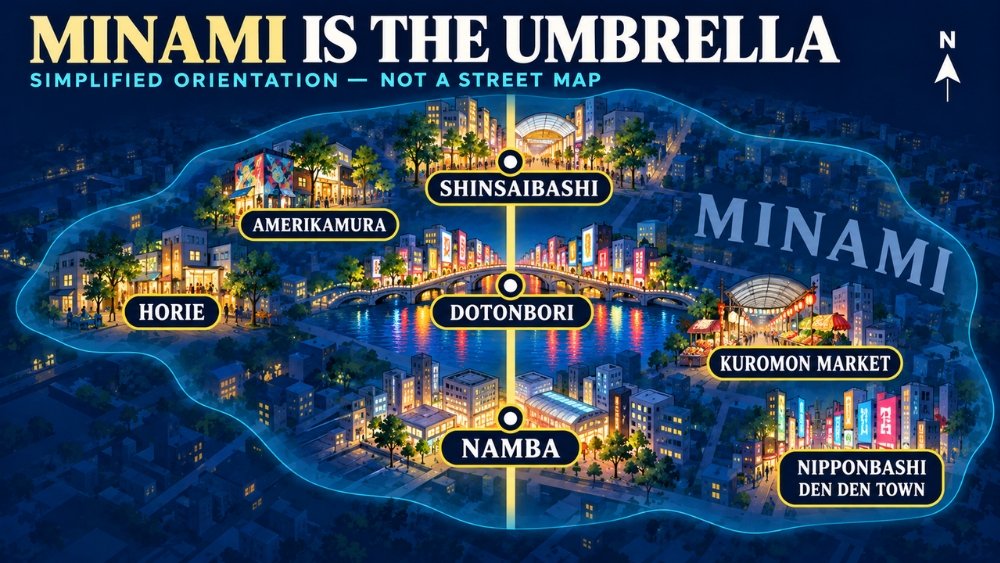
Minami is the umbrella name for Osaka’s southern downtown. Namba is its main transport hub, Shinsaibashi is the shopping spine to the north, and Dotonbori is the canal-side entertainment area between them. Amerikamura and Horie sit to the west; Kuromon Market and Nipponbashi extend the area east and southeast.
That distinction matters because there is no “Minami Station” and no single official boundary. If a hotel, restaurant or friend says “Minami,” ask for the exact station, exit or landmark. For a first visit, the least confusing plan is to start at Shinsaibashi Station, walk south through the covered shopping arcade and Dotonbori, then finish near the Namba station that matches your onward train.
| Name | What it means for your day |
|---|---|
| Minami | The wider downtown area; useful for orientation, not as a meeting point |
| Namba | The southern transport anchor, with separate Nankai, Osaka Metro, Kintetsu/Hanshin and JR facilities |
| Shinsaibashi | The northern shopping anchor and easiest start for a north-to-south first walk |
| Dotonbori | The canal, Ebisu Bridge and dense restaurant/sign district between Shinsaibashi and Namba |
| Amerikamura and Horie | West-side detours for youth culture, vintage shops, design stores and cafés |
| Kuromon and Nipponbashi | East-side detours for the market, kitchen supplies, electronics and hobby shops |
Start where your train actually arrives
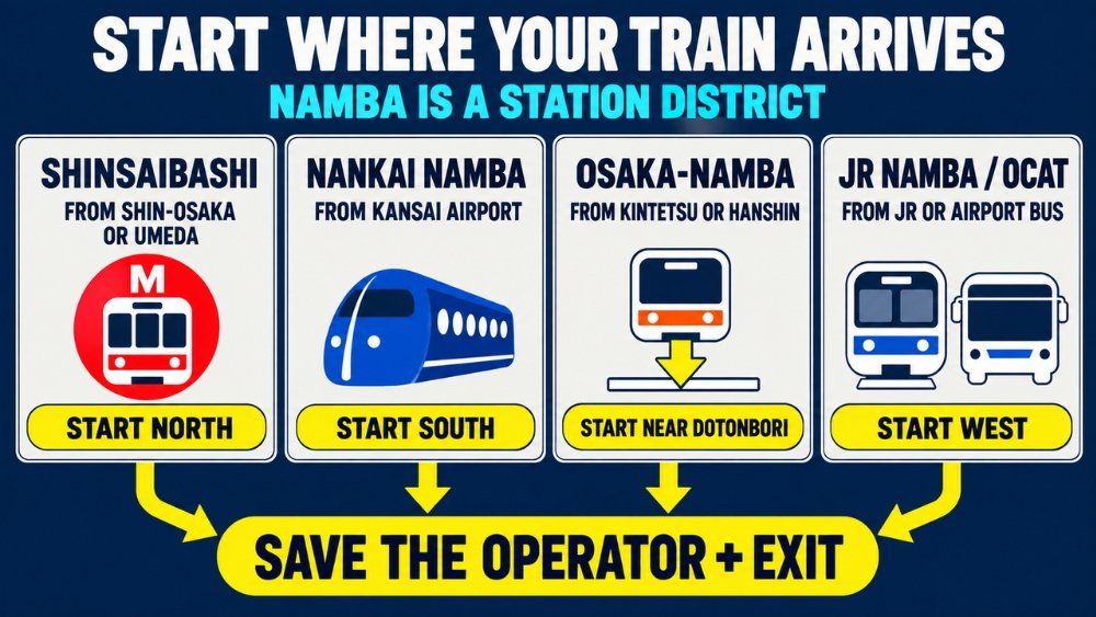
“Namba Station” is a group of connected and nearby stations, not one compact building. Osaka City’s current barrier-free planning area treats JR Namba, Nankai Namba, Kintetsu Osaka-Namba and Osaka Metro Namba as separate facilities within a wider station district. Choose the operator before you choose an exit.
| Where you are coming from | Useful arrival | What to know |
|---|---|---|
| Shin-Osaka or Umeda | Shinsaibashi on the Osaka Metro Midosuji Line | Best for walking the main shopping spine from north to south |
| Kansai International Airport | Nankai Namba | Nankai’s Rapi:t takes as little as 34 minutes, has reserved seats and requires a limited-express ticket in addition to the base fare; Airport Express trains also serve Namba |
| Nara or Kobe on Kintetsu/Hanshin | Osaka-Namba | Convenient for Dotonbori, but do not follow signs for Nankai Namba unless that is your next train |
| JR Yamatoji Line or an airport bus to OCAT | JR Namba / OCAT | This is on the western side of the Namba area; allow extra walking time to Dotonbori or the Nankai terminal |
| Elsewhere in central Osaka | Osaka Metro Namba | Three subway lines meet here; check the line letter and exit map before going to street level |
An IC card—a rechargeable tap-to-pay transit card such as ICOCA, Suica or PASMO—works for ordinary rides on the participating rail and subway networks. It does not replace the separate limited-express ticket needed for the Rapi:t. If this is your first time using one, see our ICOCA guide for Osaka.
Large suitcases make the crowded shopping streets hard to use. Leave bags at your hotel or check a station’s official locker map before you arrive; a locker shown on a map may still be occupied. For a step-free route, use the elevator path on the exact operator’s station page rather than assuming the nearest numbered exit has a lift.
Official station information: Osaka Metro Namba, Osaka Metro Shinsaibashi, Nankai Namba, and Nankai Rapi:t.
Walk the north-to-south spine first
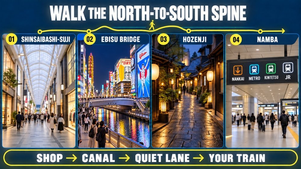
The simplest first walk is not a loop. It is a straight mental line from Shinsaibashi to Namba, with Dotonbori in the middle.
1. Enter Shinsaibashi-suji near Shinsaibashi Station
From Shinsaibashi Station, follow signs toward Shinsaibashi-suji Shopping Street. The long arcade has a pale, high roof and dense storefronts on both sides, so it is easier to follow than the parallel main roads. The roof helps in rain and strong sun, but road crossings and the later canal section are outdoors.
Do not treat the arcade as one venue with one opening time. Individual shops, cafés and department stores set their own hours. If a particular store matters, check it separately. The shopping-street association gives a 15-minute walk from Nankai Namba to the arcade, which is a useful reminder that Namba and Shinsaibashi are close but not interchangeable.
Open Shinsaibashi-suji in Google Maps or compare it with other arcades in our guide to Osaka’s shopping streets.
2. Use Ebisu Bridge as the Dotonbori checkpoint
Continue south until the arcade reaches Ebisu Bridge and the Dotonbori Canal. This is the recognizable photo area, but it is also a bottleneck. Take your photo without stopping in the center of the pedestrian flow, then decide whether to stay at street level or use the canal-side Tombori River Walk.
The River Walk has access points along both banks, and its operator lists short walks from several different Namba stations. That makes it useful as a lower-level east–west path, but stairs and access-point placement can change the easiest route for someone using a wheelchair, stroller or heavy luggage.
Open Ebisu Bridge in Google Maps and read our Dotonbori guide for a calmer route beyond the busiest crossing.
3. Make Hozenji a short, quiet detour
From the east side of the canal, turn toward Hozenji Temple and Hozenji Yokocho. The temple is small; the adjoining lane is narrow, stone-paved and lined with low restaurant fronts and warm lanterns. It is a different scale from Dotonbori only a few minutes away.
Hozenji is an active Buddhist temple, not a themed alley. Keep the approach clear, follow posted instructions and do not photograph people at close range while they are praying. In rain, the stones can be slick.
Check the official Hozenji site and open Hozenji in Google Maps.
4. Finish on the Namba side that you actually need
After Hozenji, walk south through Ebisubashi-suji or Sennichimae toward Namba. Ebisubashi-suji is a covered arcade of about 370 metres, while the streets around Namba add restaurants, comedy venues and shopping complexes. Stop checking the generic word “Namba” and follow the name of your operator: Nankai, Osaka Metro, Kintetsu/Hanshin, or JR.
If you are staying nearby, our Namba hotel-area guide explains why the correct station side matters after a late dinner.
Add one detour, not all of them
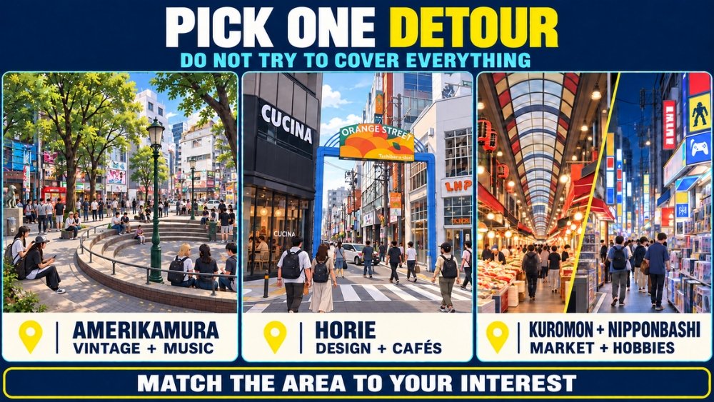
Trying to cover every side district turns an easy first walk into repeated east–west crossings. Pick one branch that matches what you actually want to see.
West: Amerikamura for youth culture, then Horie for a slower reset
Amerikamura, often shortened to Amemura, is west of Shinsaibashi-suji. Its merchant association describes vintage clothing, records and youth culture, and gives a walk of about three minutes from either Shinsaibashi or Yotsubashi Station. The small triangular public space known as Triangle Park is a meeting point rather than a landscaped park.
Continue farther west across Yotsubashi-suji for Horie and Orange Street. The local business association identifies Orange Street as the roughly 800-metre Tachibana-dori, an area with a furniture-making history that now mixes interiors, fashion and cafés. This branch suits readers who want smaller shops and a less compressed street scene than central Dotonbori.
Open Amerikamura in Google Maps or Orange Street in Google Maps.
East: Kuromon and Nipponbashi for food, tools and hobby shopping
Kuromon Ichiba Market is a covered market east of central Namba. Check the displayed price and portion before ordering rather than assuming every stall has the same value or payment method. Shops operate independently, so one map cannot guarantee that a specific stall will be open.
Farther south, Nipponbashi Den Den Town and Ota Road focus on electronics, components, games, anime and hobby shops. The official district site publishes a current shop list and map. Do not confuse this Osaka Nipponbashi with Tokyo’s Nihonbashi; the Japanese characters are the same, but the reading and city are different.
Open Kuromon Market in Google Maps or Den Den Town in Google Maps.
Central Namba: comedy or kitchenware without another district crossing
If you prefer to stay close to the transport hub, choose one Namba interest. Namba Grand Kagetsu publishes performance schedules and tickets on its official site; many performances are in Japanese, so check the programme rather than assuming every show has language support. Nearby Sennichimae Doguyasuji specializes in cookware, knives, tableware and food-display supplies.
Official links: Namba Grand Kagetsu, Kuromon Market, Nipponbashi Den Den Town, and Amerikamura.
Plan for the frictions that change the day
- Crowds: Ebisu Bridge and the adjoining Dotonbori streets can become slow-moving. If the bridge is packed, take the photo from the edge, keep moving and use a side street or the River Walk instead of forcing a straight line.
- Rain and heat: Shinsaibashi-suji and Ebisubashi-suji are covered for much of their length, but Dotonbori, Hozenji, Amerikamura, Horie and the walks between arcades are not fully protected.
- Mobility: “Nearest exit” is not always “nearest elevator.” Check the official station map for your operator and plan the surface route from that elevator.
- Luggage: Do not build the walk around finding an empty locker after arrival. Store bags before entering the busiest streets whenever possible.
- Meeting someone: Use an operator, exit number and landmark—such as “Osaka Metro Namba Exit 14”—rather than “Namba” or “Minami” alone.
- Last train: Nankai, Osaka Metro, Kintetsu/Hanshin and JR have different timetables and station entrances. Check the final train on the operator’s own route search before sitting down for a late meal.
A workable first Minami plan
Allow half a day if you want time to browse, eat and stop for photographs. Start at Shinsaibashi, follow the arcade south, pause at the canal, take the short Hozenji detour and finish at the Namba station you need. Add Amerikamura/Horie or Kuromon/Nipponbashi only if that branch is a real priority.
This route works because it turns a loose local name into one clear sequence: Shinsaibashi for the start, Dotonbori for the middle, Namba for the finish. Once you can picture that spine, “Minami” stops being a confusing word and becomes a district you can navigate deliberately.